AUTORE: METEOEVENTI – [email protected]
METEO WEEK-END: ITALIA NELLA MORSA DEL MAL TEMPO
Carissimi amici di RIWMAG e METEOEVENTI bentornati all’aggiornamento meteo del fine settimana oramai alle porte.
La tendenza instabile, cominciata nel mese di maggio, continua a resistere sulla nostra penisola.
Infatti, una vasta area di bassa pressione, estesa dal nord Europa fino al Mediterraneo, continua a far fluire impulsi perturbati sull’Italia che sono la causa del mal tempo abbastanza diffuso di questi giorni.
Nel week-end le cose non andranno a migliorare: la perturbazione non avanzerà nel suo “naturale” spostamento verso levante, bloccata ad est dalla presenza di un’area di alta pressione. Inoltre, al Sud un minimo di pressione al suolo si sposterà dalla Tunisia verso il canale di Sicilia, continuando ad alimentare il generale mal tempo sul “Bel Paese”. La situazione sarà in leggero miglioramento durante la giornata di domenica, grazie all’indebolimento del minimo di pressione al sud Italia.
In questo contesto di mal tempo diffuso, il gradiente barico al suolo che si genererà grazie allo spostamento del minimo barico al sud, sarà foriero d vento, ma, come detto, in un contesto di generale mal tempo.
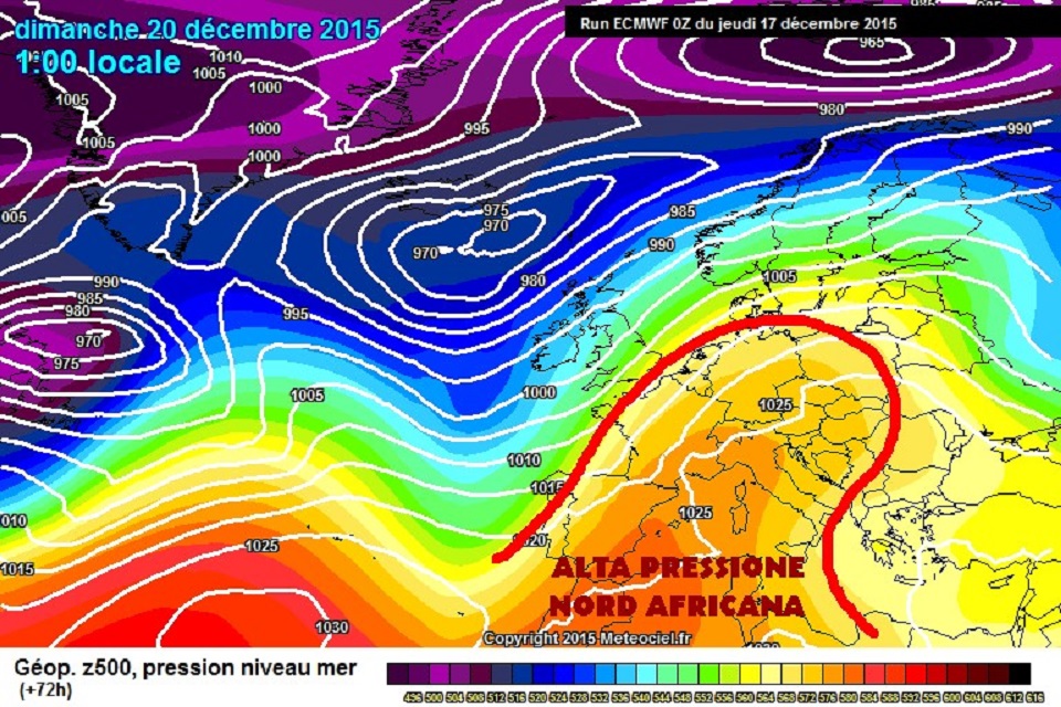
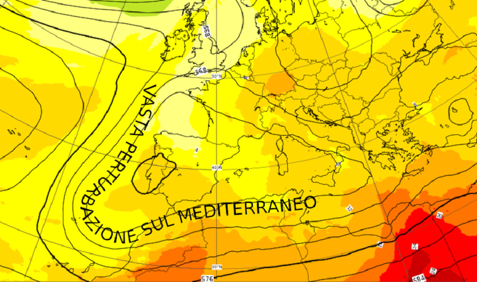
Pressione (altezza di geopotenziale isolinee nere) e temperatura (a colori) previste per la notte tra sabato e domenica. Il bacino del Mediterraneo risulterà sotto la morsa di una vasta perturbazione che porterà mal tempo diffuso sulla penisola (fonte ECMWF www.ecmwf.int ed elaborata da METEOEVENTI).

Vediamo insieme dove avremo maggiori chances di uscire con le nostre attrezzature.
SABATO
NORD versante tirrenico: attesa la Tramontana sui 18/20 nodi tra Genova e Savona con tendenza alla rotazione dai quadranti di levante dalla tarda mattinata nell’Imperiese, dove potrà raggiungere intensità sui 25 nodi. La giornata sarà, tuttavia, perturbata con rovesci e temporali, più probabili tra Genovese Savonese;
versante adriatico: poco ventose le coste adriatiche. Da segnalare una debole Bora scura sui 12/15 nodi sulle coste friulane e venete al mattino.
Sui grandi laghi atteso tempo perturbato con pioggia.
CENTRO lato tirrenico: giornata perturbata in particolare al mattino. Attese, dunque, piogge e temporali, con venti da Nordest sui 15 nodi al mattino, in rotazione da Sudest nel corso del pomeriggio a partire dalle coste laziali fino a quelle grossetane con intensificazione fino a 20 nodi;
lato adriatico: nulla da segnalare.
SUD lato adriatico: nulla da segnalare;
lato ionico: attesi venti dai quadranti di Levante. Intensità sui 15 nodi in Salento, 15/18 nodi sugli spot calabresi, dove, tuttavia, il tempo sarà caratterizzato da piogge e temporali anche di un certo rilievo (ATTENZIONE alle allerte che verranno emesse);
lato tirrenico: ben ventilato per Levante sui 25/28 nodi il versante tirrenico, in particolare sulle coste calabresi. Tuttavia, anche qui avremo mal tempo diffuso con piogge e temporali anche intensi.
Gli spot affacciati allo Stretto di Messina saranno sotto l’influsso della parte attiva della perturbazione. Atteso, quindi, vento da Sudest sui 22/25 nodi, ma anche pioggia e temporali.
ISOLE Sardegna: giornata all’insegna del mal tempo su tutte le coste sarde, sebbene una buona ventilazione da Levante interesserà la parte nord dell’Isola con intensità sui 22/25 nodi e la Tramontana soffierà sulle coste del levante sardo sui 15/18 nodi;
Sicilia: venti di Levante soffieranno su molte coste delle Trinacria. In particolare, sono attesi sui 25/28 nodi nel Messinese e a sud dell’Isola, dove avremo un’attenuazione della ventilazione nel corso del pomeriggio. Il tempo sarà perturbato sulla parte ionica con piogge e temporali anche intensi (ATTENZIONE alle allerte che verranno diramate), mentre a sud il mal tempo arriverà in serata.
DOMENICA
NORD la Tramontana continuerà a soffiare sulle coste liguri tra Genovese e Savonese (15/18 nodi) con solita tendenza alla rotazione dai quadranti di Levante verso l’Imperiese (18/20 nodi). Il contesto continuerà, tuttavia, ad essere perturbato con pioggia in particolare al mattino.
Nulla da segnalare sul versante adriatico.
CENTRO nulla da segnalare.
SUD parte adriatica: solo la parte salentina del canale di Otranto potrà goder di una ventilazione da Nord sui 12/15 nodi in uno scenario meteo con pioggia al primo mattino;
parte ionica: da segnalare una buona ventilazione dai quadranti di Levante sugli spot più meridionali del Reggino, in particolare quelli affacciati allo Stretto di Messina dove sono attese intensità fino a 18/20 nodi in un contesto lievemente perturbato con possibilità di qualche rovescio;
parte tirrenica: i venti di Levante soffieranno sugli spot interni dei golfi di Sant’Eufemia e Gioia (15/18 nodi) ed il tempo tenderà ad essere più asciutto sebbene qualche rovescio temporaneo potrà sorgere nelle ore centrali della giornata.
ISOLE Sardegna: attesa nuovamente una giornata all’insegna del mal tempo;
Sicilia: anche qui il mal tempo sarà il protagonista, in particolare al mattino, con temporali anche di un certo rilievo in transito da ovest verso est.
Buon fine settimana e … MAY THE WIND BE WITH YOU!
Stay tuned with METEOEVENTI
text: www.RIWmag.com