AUTORE: METEOEVENTI – [email protected]
METEO WEEK-END: COMINCIA LA PRIMAVERA METEOROLOGICA
Cari amici di RIWMAG e METEOEVENTI bentornati. E’ cominciata, puntuale con l’inizio del mese di Marzo, la primavera meteorologica, ma il tempo sembra essere non proprio “primaverile”.
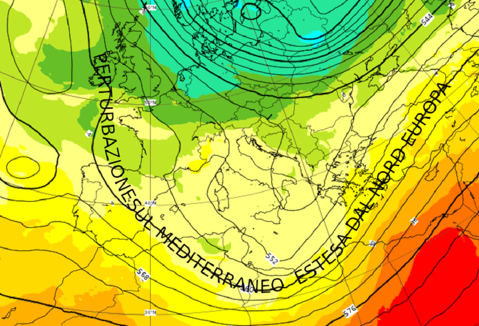
Infatti, una vasta area di bassa pressione avvolge il nostro continente, estendendosi dal nord Europa fino a interessare le regioni del Mediterraneo.
Sabato e domenica, la situazione meteorologica sarà ancora nelle mani della perturbazione dal nord Europa. L’alta pressione rimarrà, dunque, confinata al largo delle coste atlantiche e sul Mare Nostrum il gradiente di pressione sarà modesto con vento che interesserà maggiormente le isole maggiori.
Pressione (altezza di geopotenziale isolinee nere) e temperatura (a colori) previste per la notte tra sabato e domenica. L’alta pressione rimane lontana dal Mediterraneo che risulta, invece sotto l’azione di una vasta perturbazione estesa dal nord Europa (fonte ECMWF www.ecmwf.int ed elaborata da METEOEVENTI).

Aiutiamoci, come di consueto, con lo specchietto riassuntivo dei venti attesi nel week-end alla ricerca delle condizioni più favorevoli.
SABATO
NORD versante tirrenico: al mattino, una modesta Tramontana soffierà tra le coste genovesi e quelle savonesi (15/18 nodi), ma sarà in attenuazione già in mattinata, per lasciare il posto, dal pomeriggio, ad una debole ventilazione di Libeccio sui 10/12 nodi, attesa tra le coste imperiesi e quelle savonesi;
versante adriatico: attesa una ventilazione di Maestrale sulle coste marchigiane a nord di Ancona (15 nodi).
Sui grandi laghi alpini avremo una tendenza da nord legata ad un gradiente di pressione sufficiente ad alimentare episodi di Favonio.
CENTRO lato tirrenico: una buona ventilazione dai quadranti settentrionali soffierà sulle coste livornesi e grossetane (15/18 nodi);
lato adriatico: vento da Nord-Nordovest soffierà lungo le coste marchigiane ed abruzzesi con intensità media sui 15 nodi Atteso, tuttavia, tempo perturbato con pioggia in Abruzzo.
SUD il sud Italia sarà nelle grinfie della parte più attiva della perturbazione, con associate piogge e temporali.
Sugli spot dello Stretto la pioggia sarà meno continua ed il vento soffierà da Nord sui 15 nodi.
ISOLE Sardegna: il vento soffierà sulle coste del levante sardo con direzione Nord ed intensità media sui 15 nodi. La ventilazione sarà più generosa in Gallura dove i valori raggiungeranno anche i 18 nodi. Inoltre, la Tramontana ruoterà dai quadranti orientali lungo le coste sudorientali andando ad interessare anche la parte meridionali dell’Isola;
Sicilia: le coste siciliane non verranno risparmiate dalla perturbazione. La giornata risulterà grigia con piogge e rovesci, ma non continui. La ventilazione soffierà prevalentemente da Ovest-Nordovest sulle coste del Trapanese, dove, tuttavia, la pioggia sarà più costante, e sulle coste a sud dell’Isola dal pomeriggio con attesi fino a 18/20 nodi.
DOMENICA
NORD versante tirrenico: attesa una debole ventilazione di Levante al mattino sul Genovese sui 12/15 nodi. Le coste livornesi verranno raggiunte dal Libeccio nel corso del pomeriggio ed arriverà a soffiare fino a 18/20 nodi al tardo pomeriggio;
versante adriatico: nulla da segnalare.
Sui grandi laghi alpini la giornata risulterà soleggiata e ciò potrà favorire del vento ad evoluzione diurna tipico di ciascuno spot.
CENTRO lato tirrenico: nulla da segnalare fino al pomeriggio, quando è atteso un aumento della ventilazione da Nordovest sugli spot laziali a sud di Roma e del Viterbese (fino a 15/18 nodi al tardo pomeriggio);
lato adriatico: nulla da segnalare.
SUD lato adriatico: il Maestrale caratterizzerà le coste pugliesi soffiando mediamente sui 15/18 nodi, ma con intensità maggiori tra il Brindisino ed il Leccese. La pioggia continuerà a cadere al primo mattino sulla parte salentina, ma lascerà spazio ad ampie schiarite già nel corso della mattinata. Risulterà meno ventilato il golfo di Manfredonia;
lato ionico: il Maestrale soffierà sulle coste tarantine e del Leccese, ma sarà accompagnato, al mattino, dalla pioggia. Nel corso della mattinata e, soprattutto del pomeriggio, ci sarà spazio per ampie schiarite, ahimè accompagnate da un calo della ventilazione. Risulteranno, altresì, ventosi gli spot affacciati al golfo di Squillace per vento da Ponente in intensificazione da metà mattina fino a 20/22 nodi;
lato tirrenico: nulla da segnalare.
Gli spot affacciati allo Stretto di Messina godranno della tipica ventilazione da Nord dello Stretto con intensità sui 20/22 nodi.
ISOLE Sardegna: giornata di Maestrale che soffierà sui 15 nodi sulle coste del ponente sardo, 15/18 nodi a nord con intensità maggiori in Gallura ed in particolare sugli spot prospicienti le Bocche di Bonifacio (22/25 nodi). A sud dell’Isola il vento da Nordovest soffierà sui 18/20 nodi, mentre le coste del levante sardo risulteranno meno ventose;
Sicilia: anche la Trinacria verrà raggiunta dal Maestrale. Il vento da Nordovest soffierà, in particolare da fine mattinata, sui 18/20 nodi sul Trapanese e sulle coste meridionali dell’Isola. A nord il vento prevalente sarà più occidentale con intensità medie sui 15 nodi e con possibilità di qualche rovescio.
Buon fine settimana a tutti e, come al solito …
MAY THE WIND BE WITH YOU! Stay tuned with METEOEVENTI
text: www.RIWmag.com