AUTORE: METEOEVENTI – [email protected]
WEEK-END: LA “QUIETE” DOPO LA TEMPESTA
Ben ritrovati amici di RIWMAG e METEOEVENTI. Un nuovo fine settimana alle porte, cosa ci porterà in serbo?
Il titolo parla chiaro: in questi giorni una vera e propria tempesta interesserà le regioni dell’estremo sud Italia. E’, infatti, in formazione un ciclone simil tropicale (TLC in gergo Tropical Like Cyclone), parente stretto delle tempeste tropicali che sfociano negli uragani nell’oceano.
Tale struttura depressionaria interesserà principalmente Sicilia e Calabria oggi e domani, ma nel week-end la rimonta dell’alta pressione sulle regioni occidentali europee riporterà la quiete.
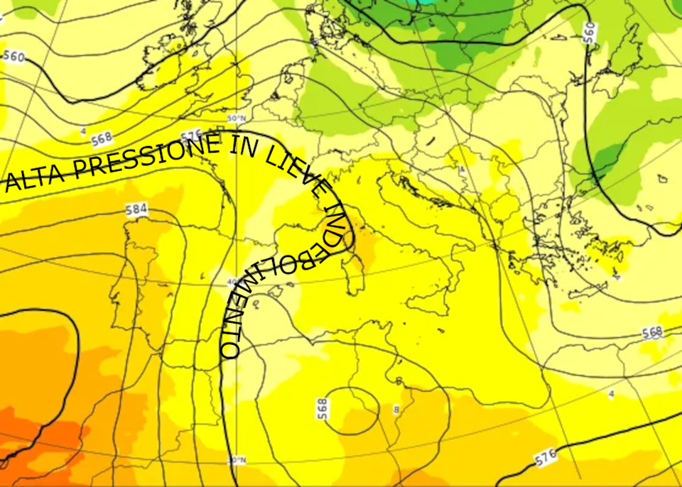
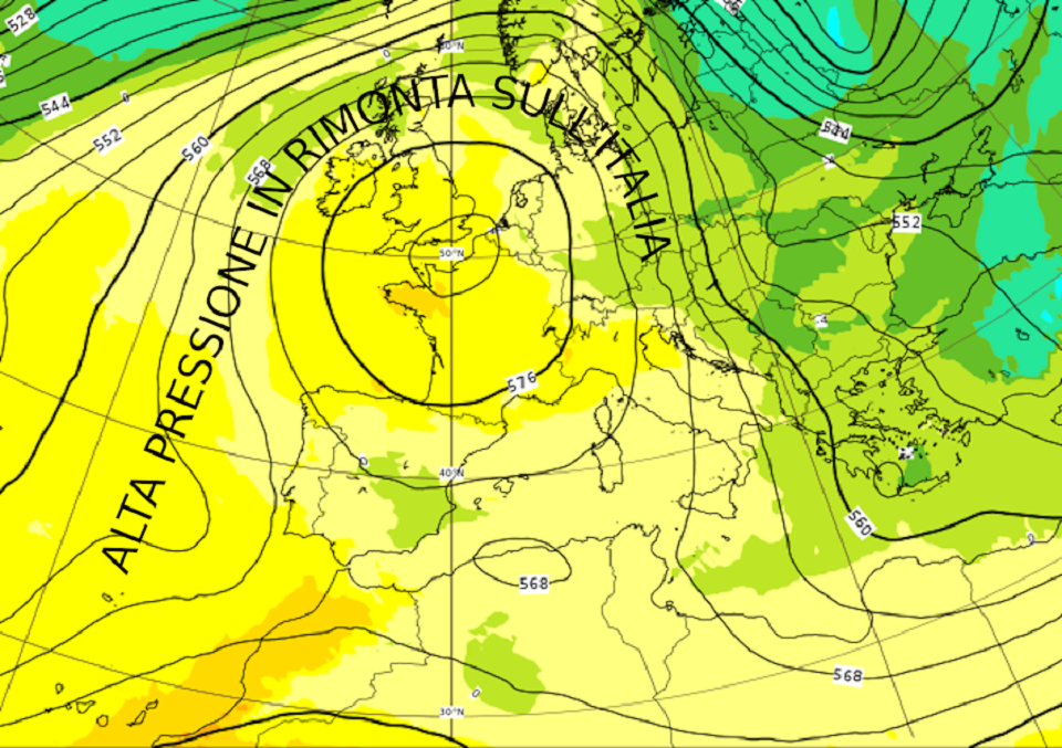
Pressione (altezza di geopotenziale isolinee nere) e temperatura (a colori) previste per la notte tra sabato e domenica. L’alta pressione rimonta sulla parte occidentale del continente interessando la nostra penisola, contribuendo a scalzare verso est la perturbazione (fonte ECMWF www.ecmwf.int ed elaborata da METEOEVENTI).

Cerchiamo di capire quanta quiete avremo sugli spot italiani.
SABATO
NORD versante tirrenico: nulla da segnalare sulle coste tirreniche del nord Italia;
versante adriatico: le coste dell’Anconetano vedranno una ventilazione di Maestrale soffiare al mattino sui 12/15 nodi, in attenuazione nel corso del pomeriggio.
Poco ventosi risulteranno anche i grandi laghi alpini per uno scarso gradiente di pressione sulle Alpi.
CENTRO lato tirrenico: anche la parte tirrenica del centro Italia sarà poco ventosa. Solo le coste del Grossetano potranno vedere intensificarsi una seppur debole ventilazione da nord (10/12 nodi).
lato adriatico: un debole vento di Maestrale tenderà a scorrere al largo delle coste adriatiche del centro Italia. Potremo comunque avere intensità prossime ai 10 nodi.
SUD lato adriatico: un debole Maestrale interesserà la parte alta del Gargano 10/12 nodi, mentre venti di Ponente soffieranno sulle coste baresi e brindisine con intensità fino a 18/20 nodi;
lato ionico: atteso vento da nord di intensità media sui 20/22 nodi. Interessate saranno le coste dal Molise al Salento. Il vento da Nord si dirigerà verso il Crotonese dove soffierà sui 22/25 nodi passando al largo delle restanti coste calabresi;
lato tirrenico: nulla da segnalare.
ISOLE Sardegna: nulla da segnalare;
Sicilia: venti da Nord-Nordest interesseranno il Siracusano e le zone ragusane limitrofe con intensità sui 18/20 nodi.
DOMENICA
NORD versante tirrenico: una nuova giornata tranquilla e con poco vento;
versante adriatico: nulla da segnalare anche su tale versante.
Anche sui grandi laghi alpini la giornata non sarà ricordata per il vento.
CENTRO versante adriatico: il Maestrale comincerà a soffiare già in mattinata sulle coste del Grossetano con intensità sui 15/18 nodi. Altrove avremo nuovamente una giornata con poco vento;
versante tirrenico: sull’Anconetano comincerà a soffiare un debole vento da Nordest nel corso del pomeriggio raggiugendo intensità sui 10/12 nodi. Più a sud il vento prevalente sarà ancora di Maestrale sui 12/15 nodi più probabile sulle coste al confine tra Abruzzo e Molise.
SUD versante adriatico: il Maestrale soffierà al mattino su gran parte delle coste pugliesi con intensità media sui 15/18 nodi. Da metà mattinata il Nordovest tenderà a disporsi più da Nord interessando al primo pomeriggio il Gargano e le coste baresi (15 nodi) spingendosi nuovamente verso il Salento nel corso del pomeriggio;
versante ionico: mattinata di Maestrale più probabile sulle coste salentine (15/18 nodi). Successivamente il vento ruoterà da Nord intensificando fino a 20 nodi ed interessando tutte le coste pugliesi e molisane per poi spingendosi verso il Crotonese dove raggiungerà intensità maggiori e sui 20/22 nodi;
versante tirrenico: nulla da segnalare fino al tardo pomeriggio, quando si intensificherà il vento da nord sulle coste campane dove raggiungerà intensità di 15/18 nodi.
Sugli spot dello Stretto di Messina avremo la tipica ventilazione da Nord, sui 18/20 nodi.
ISOLE Sardegna: un po’ di vento dai quadranti occidentali soffierà al mattino in Gallura (15 nodi). Nel corso del pomeriggio avremo una rotazione da Nordovest con intensità previste sui 15 nodi sempre in Gallura e sulla parte sudoccidentale dell’Isola;
Sicilia: atteso vento da Nord sul Trapanese dove intensificherà raggiungendo i 18/20 nodi in tarda mattinata. Il vento da Nord raggiungerà le coste agrigentine adiacenti con componente più da Nordovest ed intensità sui 15 nodi.
Buon fine settimana a tutti e, come al solito …
MAY THE WIND BE WITH YOU! Stay tuned with METEOEVENTI
text: www.RIWmag.com