AUTORE: METEOEVENTI – [email protected]
PERTURBAZIONE ATLANTICA NEL FINE SETTIMANA: VENTO, MA ANCHE PIOGGIA
Amici di RIWMAG e METEOEVENTI bentornati. Dopo un’assenza “tecnica” di qualche mese, rieccoci puntuali con gli aggiornamenti legati alla meteo per il fine settimana.
Ha ceduto la struttura di alta pressione sul Mediterraneo che sta causando un carenza di acqua in diverse regioni italiane, soprattutto al nord. Il suo cedimento è ad opera di una perturbazione atlantica che sta già interessando il nostro Bel Paese e continuerà ad essere l’attore meteo principale del fine settimana.
Sabato, infatti, tutta la penisola sarà sotto l’azione della bassa pressione atlantica e, al suo interno, si muoverà una struttura fredda in quota che transiterà sulle regioni del centro-nord, scavando un buon gradiente di pressione al suolo.
Domenica, un canale di bassa pressione si estenderà dalla penisola iberica fino ai Balcani, ma il gradiente barico al suolo risulterà meno intenso.
Attese, dunque, due giornate ventose, in particolare sabato, ma con pioggia che cadrà su molte delle nostre coste.
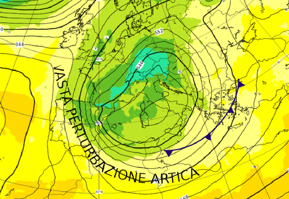
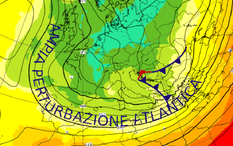
Pressione (altezza di geopotenziale isolinee nere) temperatura (a colori) previsti per la notte tra sabato e domenica. Evidenziata la struttura di bassa pressione atlantica che sarà presente sul Mediterraneo per l’intero fine settimana (fonte ECMWF www.ecmwf.int ed elaborata da METEOEVENTI).

Cerchiamo di individuare quali saranno le zone dove ci saranno più chances di trovare vento e tempo “gradevole”.
SABATO
NORD settore tirrenico: attesi venti che ruoteranno introno ad un centro di bassa pressione posizionato al mattino sull’alto Tirreno e saranno, quindi, accompagnati da tempo perturbato con pioggia in esaurimento verso il pomeriggio. Previsti venti dai quadranti di Levante dallo spezzino fino a Genova/Savona sui 15/18 nodi, mentre dal savonese verso l’imperiese il vento sarà da nordest con intensità sui 20/22 nodi. L’estinzione della pioggia vedrà anche il calo del vento, in particolare sul settore di levante.
settore adriatico: nulla da segnalare.
Sul lago Maggiore avremo una ventilazione da Nord che interesserà maggiormente la zona meridionale del lago.
CENTRO lato tirrenico: ben ventilato il settore tirrenico del centro Italia per venti di Libeccio che soffieranno sui 20/22 nodi dal grossetano fino alle coste di Roma e Latina. Il tempo, tuttavia, non sarà dei migliori, con pioggia intermittente al mattino e più continua dal pomeriggio;
lato adriatico: più asciutte le coste adriatiche, ma anche meno ventose. Chances di vento maggiori le troveremo sulle coste tra Abruzzo e Molise per venti da Sud sui 15/18 nodi.
SUD versante adriatico: il Libeccio soffierà sulle coste adriatiche pugliesi sui 18/20 nodi, ma con intensità inferiori tra le coste baresi e brindisine;
versante ionico: anche le coste ioniche vedranno il Libeccio soffiare dai golfi di Squillace e Corigliano (22/25 nodi) fino alle coste salentine (18/20 nodi), lasciando più in ombra la zona di Taranto. Più a sud la ventilazione sarà meno intensa, ma sugli spot affacciati allo Stretto troveremo, al pomeriggio, il tipico vento da Nord di intensità sui 22/25 nodi;
versante tirrenico: le coste tirreniche meridionali vedranno un tempo grigio e piovoso, sebbene ventilato per Ovest-Sudovest sui 18/20 nodi.
ISOLE Sardegna: giornata perturbata con pioggia, ma molto ventosa per Maestrale che soffierà sui 28/30 nodi sulle coste di ponente e a nord dell’Isola, 22/25 nodi sulle restanti coste sarde. Ventilazione fino 35 nodi e oltre sugli spot prospicienti le Bocche di Bonifacio;
Sicilia: attesa una giornata ventosa con venti in prevalenza di Ponente che soffieranno sui 25/28 nodi sulle coste occidentali, 15/18 nodi su quelle settentrionali, 20/22 nodi a sud dell’Isola, nonché tra catanese e siracusano. La giornata risulterà anche lievemente perturbata con pioviggine intermittente.
DOMENICA
NORD versante tirrenico: avremo ancora vento dai quadranti di Levante sulle coste liguri dell’imperiese con intensità sui 15 nodi, in un contesto lievemente perturbato con pioviggine intermittente;
versante adriatico: nulla da segnalare.
Poco o nulla da segnalare sui grandi laghi del nord Italia.
CENTRO versante tirrenico nulla da segnalare;
lato adriatico poco ventose anche le coste adriatiche del centro Italia.
SUD lato adriatico: la ventilazione dai quadranti di Ponente continuerà ad interessare le coste adriatiche pugliesi fino a metà mattinata con intensità sui 15/18 nodi, per poi indebolirsi nel resto della giornata;
lato ionico: ventilati ancora i golfi di Squillace e Corigliano, I venti soffieranno dai quadranti di Ponente sui 20/22 nodi, interessando anche la zona del basso crotonese.
Gli spot affacciati allo Stretto verranno nuovamente interessati al pomeriggio dal vento da Nord sui 15/18 nodi;
lato tirrenico: le coste calabresi tirreniche risulteranno ventose al mattino per venti di Ponente sui 15/18 nodi, ma in attenuazione nel corso della mattinata ed in particolare al pomeriggio. Sarà, tuttavia, una mattinata lievemente perturbata con pioviggine intermittente.
ISOLE Sardegna: il Maestrale continuerà a soffiare sulle coste a nord dell’Isola con intensità sui 15 nodi, ma più intense in Gallura (qui attesi venti di Ponente sui 25 nodi);
Sicilia: poco ventilate le coste siciliane. Rimarranno condizioni residue di venti da Ponente sulle coste a nord dell’Isola fino a metà mattinata (attese intensità sui 15 nodi, in particolare verso il messinese.
Con questo è tutto. Lieti di potervi nuovamente essere di aiuto nella pianificazione delle vostre uscite, vi auguriamo un bel fine settimana e, come al solito …
MAY THE WIND BE WITH YOU! Stay tuned with METEOEVENTI
text: www.RIWmag.com