AUTORE: METEOEVENTI – [email protected]
SCONTRO TRA TITANI NEL FINE SETTIMANA
Amici di RIWMAG e METEOEVENTI eccoci nuovamente ai preparativi del fine settimana.
La settimana che va a concludersi ha portato molto freddo e anche neve su molte regioni in particolare al nord Italia. Vediamo se la tendenza sarà ancora la stessa oppure se il weekend ci riserverà qualche sorpresa.
Sabato, la vasta area di bassa pressione che, attualmente, si estende dal nord Europa arrivando ad interessare le coste nordafricane di Algeria e Tunisia, continuerà a influenzare il tempo sul Bel Paese, ma comincerà a contrapporsi ad un promontorio di alta pressione che, dal’Atlantico, spingerà verso le regioni più occidentali del Mediterraneo. Il minimo di pressione al suolo si sposterà verso le regioni meridionali italiane, favorendo una ventilazione di caduta sui laghi e la Bora sull’Adriatico.
Domenica la depressione nordeuropea cederà proprio sotto la spinta dell’alta pressione ritirandosi verso i paesi baltici.
Lo scontro barico tra queste due strutture meteorologiche a grande scala influenzerà molto il tempo sulle nostre coste, regalando giornate ventose, grazie al grosso gradiente di pressione che si scaverà al suolo. Domenica, inoltre, assisteremo ad un generale miglioramento del tempo su tutta la penisola.
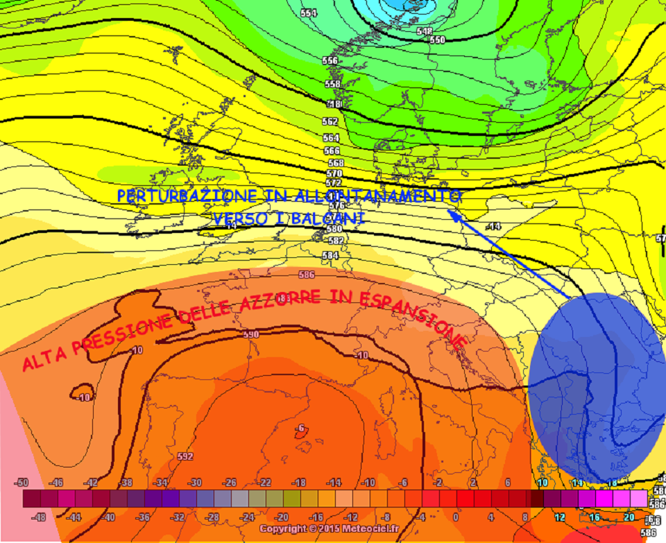
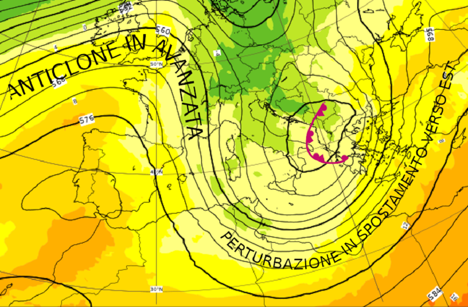
Pressione (altezza di geopotenziale isolinee nere) temperatura (a colori) previsti per la notte tra sabato e domenica. Evidenziata la perturbazione che ha portato anche la neve al nord Italia, ma in spostamento verso est grazie all’avanzata dell’anticiclone delle Azzorre. (fonte ECMWF www.ecmwf.int ed elaborata da METEOEVENTI).

Analizziamo più attentamente il fine settimana.
SABATO
NORD settore tirrenico: attesa la Tramontana tra savonese e genovese con intensità media sui 15/18 nodi, in attenuazione poi nel corso del pomeriggio. Gli spot dell’alta Toscana verranno interessati da venti da Nord sui 15/18 nodi, ma saranno in attenuazione già al mattino;
settore adriatico: soffierà la Bora sulle coste adriatiche. Il vento dai quadranti di Nordest interesserà le coste triestine sui 20/22 nodi, dirigendosi verso le coste emiliane e fino all’anconetano con direzione Nord ed intensità fino a 25 nodi. Proprio sulle coste anconetane, tuttavia, il tempo sarà perturbato con pioggia.
Sui grandi laghi è atteso il foehn. Il vento di caduta dalle Alpi soffierà forte fino a 25/28 nodi tra Maggiore e Como con direzione Nord-Nordovest e sui 18/20 nodi sul Garda con direzione Nordest.
CENTRO lato tirrenico: vento da Nord soffierà sulle coste toscane, ruotando dai quadranti di Nordovest sulle coste laziali. Attese intensità sui 15 nodi sul livornese, e fino a 28/30 nodi dal grossetano fino agli spot laziali;
lato adriatico: la Bora soffierà dai quadranti Nord sulle coste marchigiane ed abruzzesi con intensità importanti sui 25/28 nodi, ma avremo tempo perturbato dall’anconetano fino alle porte di Pescara.
SUD versante adriatico: tali coste sentiranno gli effetti di un flusso meridionale. Dunque, attesi venti da Sud-Sudovest con intensità dai 15 nodi tra barese e brindisino e fino a 20/22 nodi verso il canale di Otranto. Quest’ultimo, tuttavia, risentirà di un po’ di tempo perturbato con pioggia debole;
versante ionico: ben ventilate per venti di Libeccio le coste calabresi dal reggino al crotonese, dove avremo intensità sui 25 nodi. Il Libeccio arriverà ad interessare anche le coste ioniche salentine, ma con intensità sui 10/20 nodi e con tempo più perturbato. Sulle restanti coste ioniche dal cosentino a Taranto, il Libeccio soffierà, ma con meno costanza e con maggiore probabilità sul golfo di Corigliano.
versante tirrenico: le coste tirreniche, seppur ventose per Libeccio, saranno interessate da mal tempo con piogge per gran parte della giornata.
ISOLE Sardegna: giornata segnata dal Maestrale. Vento da Nordovest sui 25/28 nodi sulle coste meridionali e del ponente sardo, sui 18/20 nodi a nord dell’Isola e 22/25 nodi a levante. Il vento è atteso in attenuazione nel corso della giornata soprattutto a nord;
Sicilia: giornata molto ventosa per venti dai quadranti Ovest mediamente sui 28/30 nodi, ma perturbata con pioggia, in particolare a nord dell’Isola.
DOMENICA
NORD versante tirrenico: nulla da segnalare;
versante adriatico: si ritira la Bora che lascerà qualche strascico da Nordovest tra la Romagna e l’anconetano sui 12/15 nodi.
Sui grandi laghi avremo del residuo foehn al mattino.
CENTRO sul versante tirrenico poco ventose le coste tirreniche. Maggiori probabilità le avremo sulle coste laziali per Nord sui 18/20 nodi in attenuazione nel pomeriggio;
sul lato adriatico il vento da Nordovest soffierà dall’anconetano alle coste molisane con intensità sui 15/18 nodi. In Molise ci saranno maggiori possibilità di vento più intenso fino a 20/22 nodi, ma con tempo debolmente perturbato.
SUD lato adriatico: il Maestrale interesserà le coste pugliesi con intensità media sui 18/20 nodi e con tempo debolmente perturbato al mattino, ma in miglioramento proprio nel corso della mattinata;
lato ionico: anche il versante ionico verrà raggiunto dal Maestrale. Il vento da Nordovest soffierà sui 18/20 nodi sulle coste lucane e pugliesi e raggiungerà il crotonese, qui con intensità maggiori e sui 22/25 nodi. Nel corso della giornata il tempo debolmente perturbato del mattino vedrà un miglioramento.
Gli spot dello Stretto di Messina beneficeranno della ventilazione da Nord sui 20/22 nodi, ma avranno anche un po’ di pioggia debole al mattino;
lato tirrenico: qui il vento prevalente sarà da Nord ed interesserà prevalentemente le coste campane con intensità sui 15 nodi.
ISOLE le coste sarde verranno abbandonate dal Maestrale, che continuerà ad interessare, invece, quelle siciliane. In Sicilia, infatti, il vento da Nordovest soffierà sui 25/28 nodi tra palermitano e trapanese, 15 nodi sulle restanti coste a nord dell’Isola (qui accompagnato da pioggia debole) e sui 20/22 nodi tra agrigentino e ragusano.
MAY THE WIND BE WITH YOU! Stay tuned with METEOEVENTI
text: www.RIWmag.com