AUTORE: METEOEVENTI – [email protected]
FINE SETTIMANA TIPICAMENTE PRIMAVERILE
Amici di RIWMAG e METEOEVENTI bentornati. E’ cominciato il nuovo mese di Maggio e la primavera si fa sentire, interrompendo il lungo periodo di siccità che ha attanagliato molte delle nostre regioni per mesi.
Il week-end alle porte si prospetta come un tipico fine settimana primaverile, dove non mancherà il vento su molte delle nostre coste, ma sarà anche accompagnato da tempo perturbato con piogge e temporali.
Infatti, sabato una perturbazione stazionerà sul Mediterraneo centrale, con centro di azione posizionato sulle regioni meridionali della nostra penisola e la sua azione continuerà, seppur con minore vigore, anche nella giornata successiva di domenica.
La presenza del minimo di pressione al suolo al sud Italia favorirà un buon gradiente di pressione sui nostri mari ed in particolare proprio al sud del “Bel Paese”, quindi vento, ma anche tempo perturbato.
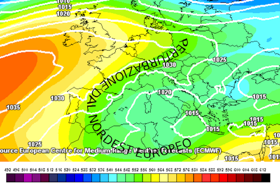
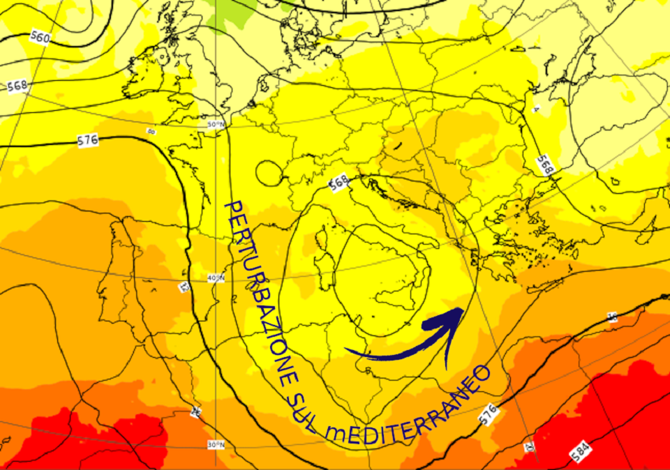
Pressione (altezza di geopotenziale isolinee nere) temperatura (a colori) previsti per la notte tra sabato e domenica. Un centro di bassa pressione strutturato a tutte le quote stazionerà sul sud Italia per l’intero fine settimana (fonte ECMWF www.ecmwf.int ed elaborata da METEOEVENTI).

Individuiamo dove avremo più chances di vento e soprattutto dove il tempo sarà più clemente per le nostre planate.
SABATO
NORD settore tirrenico: la Tramontana soffierà sui 18/20 nodi tra genovese e savonese e, nel corso della mattinata, compierà la tipica rotazione da est-nordest sulle coste del ponente ligure;
settore adriatico: nulla da segnalare.
Sui grandi laghi la giornata trascorrerà all’insegna della variabilità atmosferica con anche rovesci e temporali e ciò non favorirà la genesi dei tipici venti termici lacustri.
CENTRO lato tirrenico: da segnalare una ventilazione da Nord nel livornese con intensità media sui 15/18 nodi in un contesto meteorologico di grande variabilità;
lato adriatico: nulla da segnalare.
SUD versante adriatico: poco ventose le coste adriatiche del sud Italia. Qualche occasione di vento maggiore l’avremo sul Gargano per venti da Levante, ma con tempo perturbato;
versante ionico: decisamente più all’insegna dell’instabilità atmosferica le coste ioniche per la vicinanza al minimo di bassa pressione. In questo contesto di instabilità le coste crotonesi e cosentine saranno sotto una ventilazione da Levante mediamente sui 20/22 nodi;
versante tirrenico: instabile anche sul versante tirrenico del sud Italia con venti da Est fino a 20/22 nodi in particolare sul cosentino e catanzarese.
Gli spot affacciati allo Stretto non si esimeranno dall’instabilità atmosferica per venti da Est.
ISOLE Sardegna: giornata di mal tempo con pioggia e temporali. A nord dell’Isola l’instabilità atmosferica sarà meno pronunciata e avremo una ventilazione da nord sulla Gallura fino a 20/22 nodi. Nel corso del pomeriggio è prevista qualche schiarita sulle coste del levante sardo con un’associata ventilazione di Tramontana sui 18/20 nodi;
Sicilia: l’instabilità atmosferica interesserà anche le coste siciliane, quelle più vicine al centro d’azione della perturbazione sul Mediterraneo. Giornata, dunque, all’insegna del mal tempo seppur ventosa a sud dell’Isola per moderati venti di Ponente.
DOMENICA
NORD versante tirrenico: attiva ancora la Tramontana sui 18/20 nodi tra genovese e savonese, ma difficilmente riuscirà a compiere la rotazione dai quadranti orientali sul Ponente ligure. Attesa una giornata all’insegna della variabilità atmosferica;
versante adriatico: una debole ventilazione da Nordest soffierà tra il triestino e la laguna di Venezia, ma con intensità non oltre i 12/15 nodi.
Sui gradi laghi la giornata si presenterà nuovamente all’insegna della variabilità atmosferica con rovesci e temporali che non favoriranno l’innesco dei termici.
CENTRO le coste centrali della penisola risulteranno poco ventose.
SUD versante adriatico: nulla da segnalare;
versante ionico: le coste maggiormente ventose risulteranno quelle del crotonese per venti dai quadranti di Levante, ma proprio lì avremo nuovamente una giornata di instabilità atmosferica;
versante tirrenico: il Levante soffierà sui 15/18 nodi sule coste del cosentino dove l’instabilità atmosferica risulterà meno pronunciata. Tale ventilazione sarà in attenuazione nel corso del pomeriggio.
ISOLE Sardegna: attesi venti di Levante a nord dell’Isola che, con intensità media sui 15/18 nodi, si sposteranno, in mattinata, dalle Bocche di Bonifacio verso l’Asinara;
Sicilia: la Trinacria resterà sotto l’azione del minimo di bassa pressione che causerà una giornata di mal tempo con pioggia e temporali. Al pomeriggio qualche chance maggiore potremo trovarla tra trapanese e agrigentino per il sopraggiungere di venti di Maestrale sui 15/18 nodi.
MAY THE WIND BE WITH YOU! Stay tuned with METEOEVENTI
text: www.RIWmag.com